Basic HTML Version


26
Geotechnical News • December 2012
www.geotechnicalnews.com
GEOTECHNICAL INSTRUMENTATION NEWS
Digital photogrammetry (DP)
DP is a ground, aerial or satellite
based fully remote technique that uses
a visible passive sensor. DP collects
2D optical images from different
positions of the ground/structure, thus
achieving 3D ground models. By com-
parison of the 3D models at different
times, ground/structure deformation is
detected. The main field of application
is slope instabilities.
Differential global positioning
system (D-GPS)
D-GPS is a satellite based partially
remote technique that uses a micro-
wave active sensor. D-GPS collects
the precise position of GPS sensors
installed on the ground/structure.
By comparison of the GPS sensor
positions at different times, ground/
structure deformation is detected.
The main fields of application are
fluid extraction/pumping, tunneling in
urban areas, slope instabilities, dams
and civil buildings.
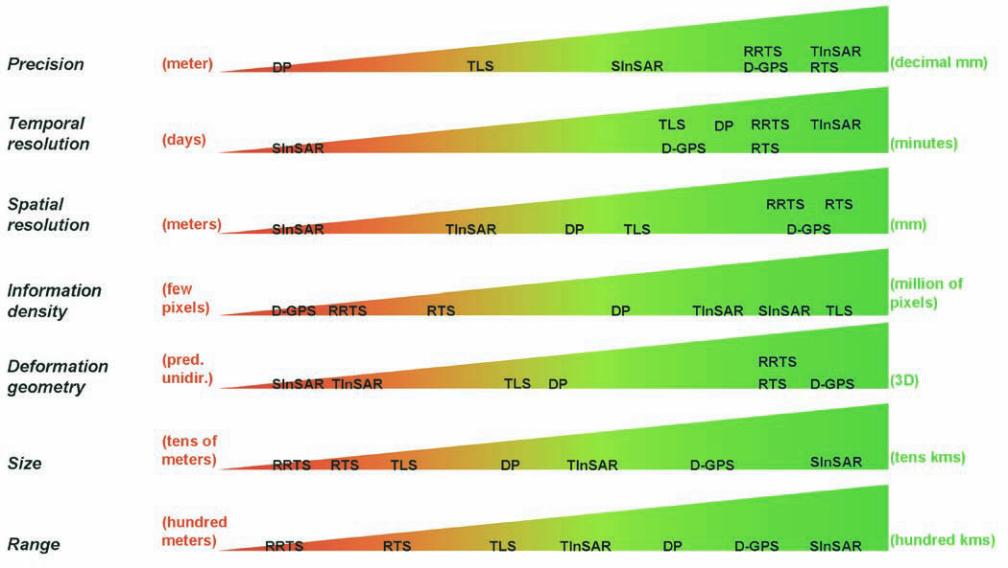
How to evaluate a remote
sensing method
In evaluating a remote sensing method
for monitoring purposes several
parameters and features must be
considered. In what follows a brief
description of the main relevant fea-
tures is presented:
• Precision
: maximum repeatability
of measurements.
• Temporal resolution
: maximum
frequency in data collection.
• Spatial resolution
: maximum reso-
lution of pixels at the ground/struc-
ture, i.e. minimum size of the area
where deformation value is pro-
vided.
• Information density
: the density of
information in terms of number of
pixels and their areal distribution.
• Deformation geometry
: geometri-
cal information of the deformation
measurement (e.g. unidirectional
predefined, unidirectional, bidirec-
tional, 3D, etc).
• Degree of interaction with the
ground/structure:
interaction with
the monitored area (from zero for
the fully remote techniques, to high
for techniques that required the in-
stallation of sensors on the ground/
structure).
• Size of the monitored area
: maxi-
mum size of the area that can be
monitored simultaneously by a
single sensor.
• Data reliability and validity
: reli-
ability of achieved results.
• Maximum operability range
: maxi-
mum distance to which the defor-
mation of a target (artificial or natu-
ral) can be determined.
• Atmospheric noise
: degree of sensi-
tivity to the atmospheric noise.
• Budget
: cost required for the moni-
toring.
For each of the above mentioned
features there is a very wide range of
variability among the techniques dis-
cussed in this article (Figure 1). Figure
2 presents a qualitative rating of the
above features. However, it must not
Figure 1. Range of variability of some features described in the text with respect to each method. The values in the
parentheses identify the “end members” (in red the worst values, in green the best values).