28


                Geotechnical News • December 2012


                www.geotechnicalnews.com


                GEOTECHNICAL INSTRUMENTATION NEWS


              of these somewhat complex methods
            
            
              runs the risk of a person being carried
            
            
              away by the excitement of innovation
            
            
              while ignoring the above words of
            
            
              wisdom.
            
            
              In what follows I will try to give some
            
            
              suggestions applicable to “doing well”
            
            
              with these seven methods for remote
            
            
              monitoring of deformation.
            
            
              First, the main advantages and limita-
            
            
              tions of each method are summarized
            
            
              in Figure 3, thus identifying the main
            
            
              opportunities offered by the methods,
            
            
              but also providing an understanding
            
            
              of constrains. For example, if you are
            
            
              looking for a short time 3D monitoring
            
            
              of deformation at a specific location
            
            
              with high data sampling frequency, it
            
            
              can be seen that SInSAR is not suit-
            
            
              able, while RTS is more appropriate. If
            
            
              you are interested in monitoring past
            
            
              deformations of a large area with high
            
            
              accuracy, you can see that SInSAR is
            
            
              probably the only available method.
            
            
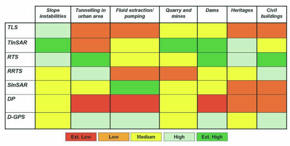
              Focusing on the geotechnical appli-
            
            
              cations is more difficult, since the
            
            
              number of cases to be considered is
            
            
              very wide, and each one is likely to be
            
            
              characterized by specific site condi-
            
            
              tions that require a unique evalua-
            
            
              tion. However, the following general
            
            
              applications are identified below and
            
            
              in Figure 4.


                  • Slope instabilities


              : monitoring of
            
            
              unstable slopes for both investigat-
            
            
              ing purposes and continuous con-
            
            
              trol.


                  • Tunneling in urban areas


              : moni-
            
            
              toring of local deformation induced
            
            
              by underground excavation.


                  • Fluid extraction and pumping


              :
            
            
              monitoring of topographic changes
            
            
              related to fluid or gas extraction
            
            
              variation both at local and regional
            
            
              scale.


                  • Quarries and mines


              : real time mon-
            
            
              itoring of slope instabilities during
            
            
              mines exploitation.


                  • Dams:


              monitoring of dams defor-
            
            
              mation for testing and control pur-
            
            
              poses.


                  • Heritage structures:


              monitoring
            
            
              of high value cultural heritage for
            
            
              safety purposes.


                  • Civil buildings:


              monitoring of stan-
            
            
              dard buildings for safety purposes.
            
            
              To emphasize with rating provided in
            
            
              Figure 4 is appropriate only for ‘stan-
            
            
              dard’ applications. The suggestions
            
            
              are not applicable for ‘non-standard’
            
            
              applications, where only a specific and
            
            
              advanced design can provide the best
            
            
              solution. For example, for the periodic
            
            
              monitoring of fast-moving landslides,
            
            
              DP or TLS can be more appropri-
            
            
              ate than TInSAR and other methods,
            
            
              while for the real-time monitoring of
            
            
              localized subsidence related to fluid
            
            
              extraction, TInSAR can be more
            
            
              appropriate than SInSAR (thus contra-
            
            
              dicting Figure 4).


                Figure 4. Qualitative evaluation of the performance offered by all the remote methods for different geotechnical appli-


                cations. From red color to green color (see at the scale bar) there is an increasing performance of the method.


                Conclusions


              Methods for remote monitoring of
            
            
              deformation are gaining popularity
            
            
              within the geotechnical commu-
            
            
              nity because they offer several new
            
            
              opportunities. Sometimes they can
            
            
              be alternatives to traditional contact
            
            
              methods, but more frequently they
            
            
              can be integrated with them. They are
            
            
              also opening new opportunities in the
            
            
              geotechnical field, such as monitoring
            
            
              for “investigative purposes. Features