Basic HTML Version


www.geotechnicalnews.com
Geotechnical News • December 2014
35
GEOTECHNICAL INSTRUMENTATION NEWS
The fundaments of wireless monitoring – Things to consider
Simon Maddison
Introduction
Although wireless sensors have been
around for some time, the take up in
the geotechnical world has been very
low to date. It is technically challeng-
ing to develop a truly robust solution
with precise and stable sensing, long
battery life and seamless mains-power
free data transmission to the user.
There are many companies and solu-
tions in the market claiming they can
achieve the above, but in reality many
market offerings are still immature.
Nonetheless wireless is now being
recognised as a practical and robust
option for geotechnical monitoring.
There are many factors to consider
with the design of any geotechnical
monitoring system, and this article is a
guide for users that specifically applies
to the use of wireless sensors and
enabling robust communication links.
As a background, and without getting
unduly technical, it includes a general
guide to the different architectures of
wireless systems with the aim of help-
ing the industry pose the right kinds of
questions.
Proven and robust wireless solutions
offer important advantages in many
situations, by reducing costs, dra-
matically cutting installation man-
power and eliminating reliability and
other issues associated with cabling.
Furthermore proven wireless is now
beginning to be recognised for open-
ing up monitoring opportunities which
would otherwise either be very diffi-
cult if not impossible to achieve. This
article rounds off with some discus-
sion as to these possibilities, to show
that wireless can be much more than
an efficient and cost saving alternative
to wired systems.
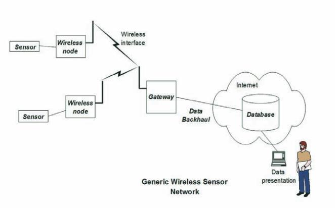
Generic wireless architecture
First let’s explore the principal ele-
ments of a generic wireless sensor
network. This is shown in Figure 1. A
sensor is connected to (or integrated
within) a wireless sensor node. One
or more of these communicate via
radio to a data collection unit, in order
to send back the measurement data.
This could be simply a data logger,
where the data is stored and manually
collected, or it could be automatically
passed back to a remote data storage
location, in which case it is commonly
described as a
gateway
. The data link
back to the remote storage is com-
monly described as
data backhaul
.
Data backhaul can be effected using
one of many different mechanisms,
for example: dial up modem; ADSL;
GSM/GPRS/3G or via a satellite link.
The solution chosen will very much
depend on the resources available in
the environment where it is installed,
which will be discussed below. Data
are then stored in some form of data
base (which could be a data warehouse
in the ‘Cloud’ or simply on a PC).
It can then be accessed by the user,
either for semi manual processing (e.g.
in a spreadsheet application such as
Microsoft Excel) or rendered graphi-
cally and dynamically by a dedicated
software package.
Other than to note that there are
some well-established commercially
available data visualisation and
management packages, and that there
continues to be rapid evolution in
graphical power and flexibility, it is
beyond the scope of this article to go
further into data rendering; the focus
will be on the wireless elements.
Additionally, although as indicated
above there may be situations where a
wireless node is simply connected to
a data logger, for the purposes of this
article a full end to end arrangement as
in Figure 1 will be assumed.
Wireless architectures for
geotechnical sensing
There are three principal wireless
architectures for sensing networks,
and these are shown in Figure 2. This
is not intended to be exhaustive, but to
Figure 1
.
Generic wireless sensor architecture.