54
Geotechnical News March 2011
WASTE GEOTECHNICS
continuous retaining dykes make up
the North, West and South portions
of the STP. Containment to the East is
provided by naturally elevated ground.
In descending order below the
ground surface, the geology at the
STP consists of 1-2m of muskeg-based
Holocene organic soil, approximately
8-15m of Pleistocene glacial till (al-
though thin (<5m) coverage has been
observed at several locations across
the site), and 20-30m of Pleistocene,
glaciofluvial dense sands and grav-
els comprising the Wood Creek Sand
Channel. The SE to NW branch of the
Wood Creek Sand Channel is the prin-
cipal flow feature and controls ground-
water conditions in the connecting off-
shoots. A “spill-point” exists beyond
the NW corner of the STP dyke, where
the Sand Channel discharges into the
McLean Creek, a tributary to the Atha-
basca River.
Suncor has identified three potential
locations for release of PA seepage wa-
ters into the environment. These will be
mitigated by: an interception pumping
well field to the NW (groundwater is
currently pumped back into the STP), a
cutoff wall to the SW, and if required,
a pumping well system in the SE (un-
der investigation) (Figure 1). These
containment measures for potentially
contaminated waters permit aquifer in-
jection experiments critical to this re-
search project.
Overview of Research
Activities
Project objectives will be realized
through a comprehensive series of
experiments, presently underway. The
intent of laboratory experiments is: a)
to characterize the hydrogeological
properties of subsurface sediments;
and b) to characterize the i) aqueous
geochemistry of pore waters, ii) solid
phase geochemistry of sediments,
and iii)
in situ
microbial communities
present in the clay till and sandy
sediments below the tailings pond,
both before and after exposure to
PA water. Results will be extended
to the field scale by c) a field study
of the infiltration rates and induced
biogeochemical reactions as PA water
infiltrates through the base of a small-
scale, constructed representation of the
STP; d) a field program to sample and
continuously monitor groundwater for
potential migration and evolution of
PA seepage from the STP; e) a field
evaluation, using controlled input of
PA water, of natural attenuation in the
sand channel aquifer; and finally f) an
evaluation of the viability of
in situ
chemical oxidation to destroy toxic
organic compounds contained in the
PA water, assuming migration into the
Sand Channel occurs.
Central to this project are three in-
strumented field research facilities: a
groundwater monitoring network to
monitor flux from the tailings pond, a
field-scale infiltration pond, and a sys-
tem of injection/sampling wells in the
Wood Creek Sand Channel (locations
shown in Figure 1). Each is described
in detail below.
Groundwater Monitoring
Network
In the Spring of 2006, a groundwater
monitoring network was established
across the West Dyke, immediately
downstream of the STP based upon
understanding of the local and regional
groundwater flow patterns, thus
permitting early detection of potential
PA water migration beneath the Pond.
The completed network consists of
4 nests of multilevel groundwater
monitoring points, together spanning
the width and depth of the glacial till
and Wood Creek Sand Channel.
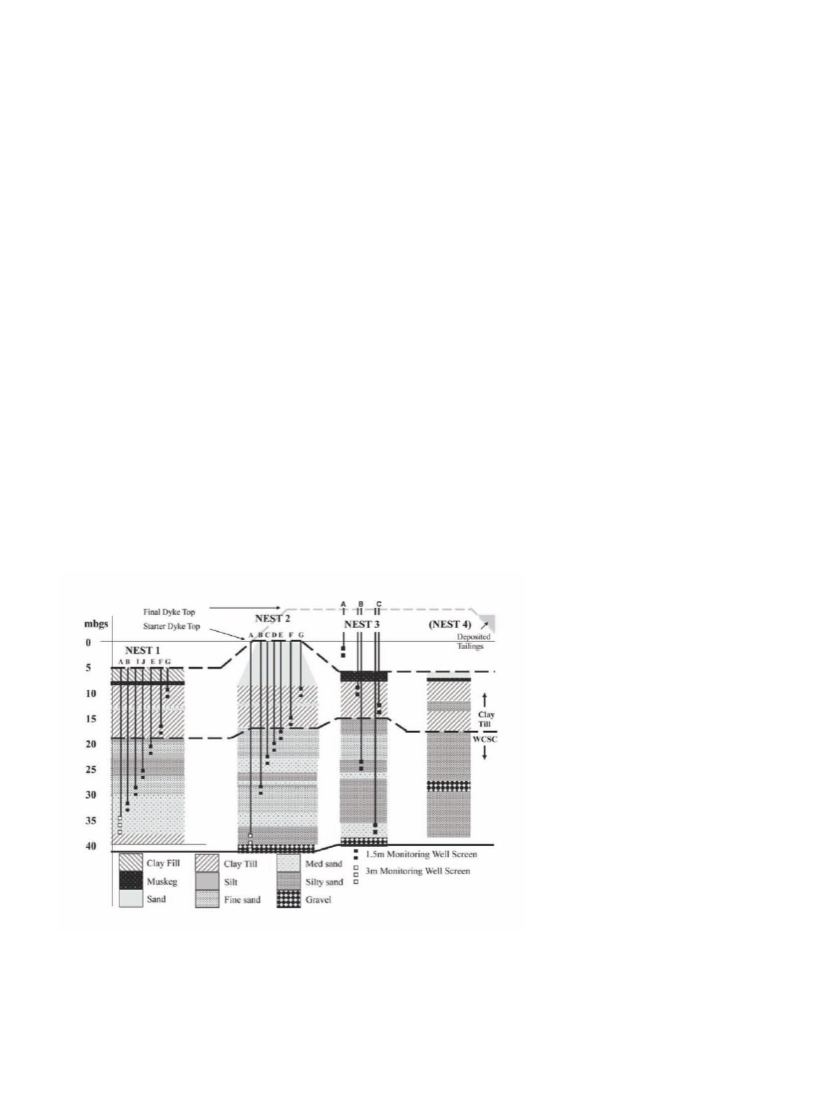
Monitoring Well Installation
Details
Nests 1 and 2 were instrumented with
seven monitoring wells each, to permit
the regular collection and geochemical
analysis of groundwater samples from
several elevations in the subsurface.
Their implementation is summarized
in Figure 2. During borehole drilling,
sediment cores were collected using
SONIC drill rig-mounted Lexan liners
and were capped at the surface to
maintain the
in situ
redox conditions.
Core samples were collected in 1.5m
lengths at the same depth intervals
as monitoring wells screens and the
Figure 2. Schematic of the vertical delineation of surficial geology by monitoring
wells at the Groundwater Monitoring Transect. Monitoring wells were constructed
from 50mm (I.D.) Schedule 80 PVC solid pipe, with 0.5mm slotted casing well
screens. Sand filter packs extend beyond the well screen by at least 0.3m in either
direction. Bentonite chips were used to grout the remaining void space up to
ground surface. (mbgs=metres below ground surface, WCSC = Wood Creek Sand
Channel).


