36
Geotechnical News • September 2018
GEOHAZARDS
to estimate the frequency, magnitude
and intensity of a landslide triggered,
for example, by a strong earthquake
during the wet season, an event that, in
coastal BC, might have a greater than
1:10,000-year probability.
A comprehensive geoscientific treat-
ment of each such case can be rather
costly, though perhaps affordable for
large-scale developments, but the
resultant uncertainty still may yield
a vague “best estimate” of the lowest
probability events that are to be con-
sidered in a risk assessment, and this
uncertainty is typically unquantifiable.
Another issue is the problem of non-
stationarity. In flood hazard analy-
sis, decadal cyclic climate drivers
may create non-stationarity, while
in landslide analysis, centuries to
millennia-scale oscillations arise from
climate shifts or sudden morphologic
watershed changes. Superimposed
on these varying climate patterns is a
millennial scale pattern of landscape
readjustment following the demise
of Pleistocene glaciers, the so-called
paraglacial period. This period was
characterized by an early Holocene
sediment pulse followed by a rapid
decline in sediment yield to “normal”
yields in the mid to late Holocene.
Thus, even in cases where radiocar-
bon dating allowed reconstruction of
landslides back to the early Holocene
era (~ 11,000 to 8,000 years ago), the
applicability of the data to estimate
the probabilities of future events could
be suspect. Juxtaposed is the com-
plication of including future climate
change, which may eventually create
event magnitudes and frequencies that
plot outside the range of reconstituted
paleo-records. Statistical treatment of
the data series ignoring these trends
would then be flawed and likely
result in erroneous estimates of future
events. The issue of non-stationarity
in the rate of geomorphic processes
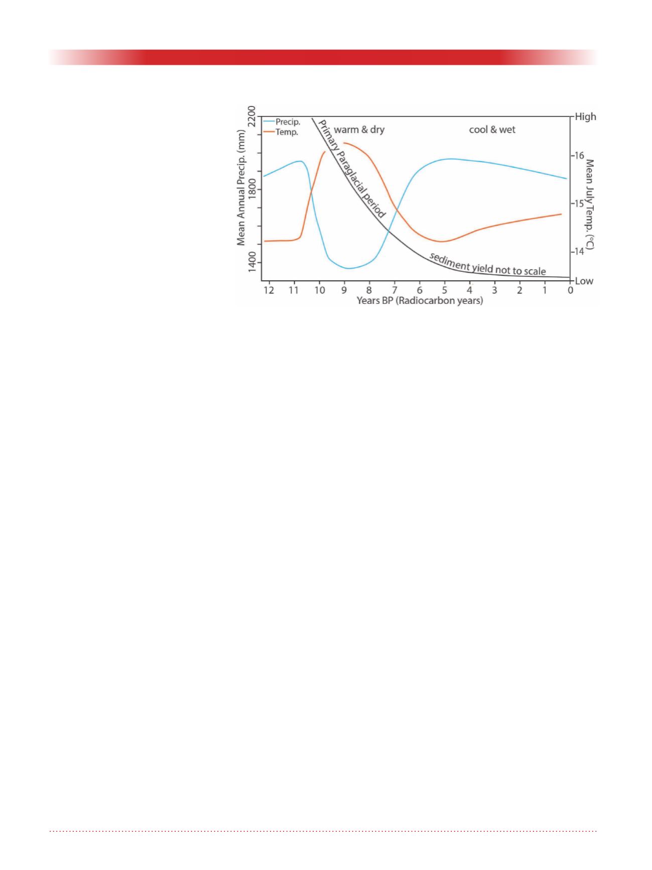
including landslides is illustrated in
Figure 1.
Finally, not all landslide processes are
spatially recurrent. Rock avalanches
rarely occur more than once in exactly
the same location because source area
depletion often precludes reoccurrence
(Cruden and Hu, 1993). Methods are
emerging to approximate rock ava-
lanche probability based on regional
inventories (Hantz et al. 2003; Catani
et al. 2016). However, application of
such methods will result in a broad
range of estimated rock avalanche
probability. If a rock avalanche is
known to have occurred within the
Holocene on a nearby slope that is
similar in other respects to the slope
being assessed, the estimated event
probability range will often encom-
pass the landmark 1:10,000-year
event. This creates a conundrum: If
the probability estimate is greater than
1:10,000, it would mean integration
into risk assessments that may show
that existing and/or future develop-
ment is at unacceptable risk. Given
that rock avalanches are unmitigat-
able in most instances at any reason-
able cost, this can create a substantial
political problem for the local govern-
ment involved unless there is a basis
for relying upon long-term monitoring
programs. If, however, the probabil-
ity estimate is lower than 1;10,000,
development may be approvable
without conditions according to hazard
acceptance criteria that are currently in
use. This can lead to progressive popu-
lation growth in the area below a cred-
ible and potentially lethal landslide
hazard, thus leading to conditions with
ever increasing risk. In this context, it
is of interest to compare BC practice
to European Nations and Japan, who
consider landslide return periods up to
300 years and rarely up to 1,000 years
(Hong Kong) in hazard or risk assess-
ments and mitigation design.
Given the tremendous uncertainty in
estimating the characteristics of very
low probability landslide events, and
conservativism with respect to explic-
itly considering a much larger range
of annual probabilities compared to
other nations with much longer experi-
ence in managing geohazard risks,
one wonders as to the origins of the
1:10,000-year landslide event guid-
ance.
The 1:10,000-year event likely has its
roots in an interpretation of the his-
toric 1973 decision by Judge Thomas
Berger with regard to a subdivision
proposed in the Cheakamus River
valley downstream of the Garibaldi
Lake Volcanic Barrier. A second phase
subdivision consisting of 126 lots on
Rubble Creek fan had been planned by
Cleveland Holdings Ltd. The senior
Figure 1. Non-stationarity of geomorphic processes due to the paraglacial
pulse with reconstructed Holocene mean annual temperature and
precipitation trends.
Image compiled after Mathewes and Heusser 1981 and
Church and Ryder 1972.


