32
Geotechnical News • June 2019
GEOHAZARDS
Identification of destabilized
rock glaciers
At a regional scale, destabilized rock
glaciers are often identified using
remote sensing techniques that pro-
vided displacement rates for a large
number of landforms. Nevertheless,
the rapid and episodic nature of the
destabilization process means that
some destabilizing rock glaciers may
be missed using this method alone
(Lambiel et al, 2011; Vivero and
Lambiel, 2019). Geomorphological
observations of rock glaciers in early
stages of destabilization, including
cracks, crevasses and scarps, can show
future occurrence of the phenomenon
(Figure 1).
This identification approach based
on geomorphological observations
was applied to the French Alps. Each
active rock glacier was inspected by
an operator that mapped the observ-
able surface disturbances in the ortho-
images provided by the IGN (National
Institute of Geography). Observations
were performed using several frames
from the period 2000 to 2015, allow-
ing the mapper to track the recent
evolution of the surface disturbances.
These observations were then used
to assign a destabilization rating to
each landform. The rating varied from
zero (undisturbed landforms) to three
(potentially destabilized landforms).
Potentially destabilized landforms
were further subdivided into two
categories for either deep surface
disturbances (crevasses and scarps,
assigned 3a) or shallow surface cracks
(assigned 3b). Rating scores of 1 or 2
were assigned to landforms with sur-
face disturbances that did not change
over the inspection interval (score of
1) or did not show a strong accelera-
tion of the frontal lobe (score of 2).
The study showed that destabilization
is common in the region, and almost
10% of the active landforms appeared
to be undergoing this change. Of 46
potentially destabilized landforms, 13
of them showed deep surface dis-
turbances. Most of these landforms
were found in two regions, the Haute
Maurienne and the Ubaye, where the
lithology is prone to be densely jointed
and composed mainly of ophiolites
and schists. We therefore infer that
landforms in these contexts are more
prone to destabilization.
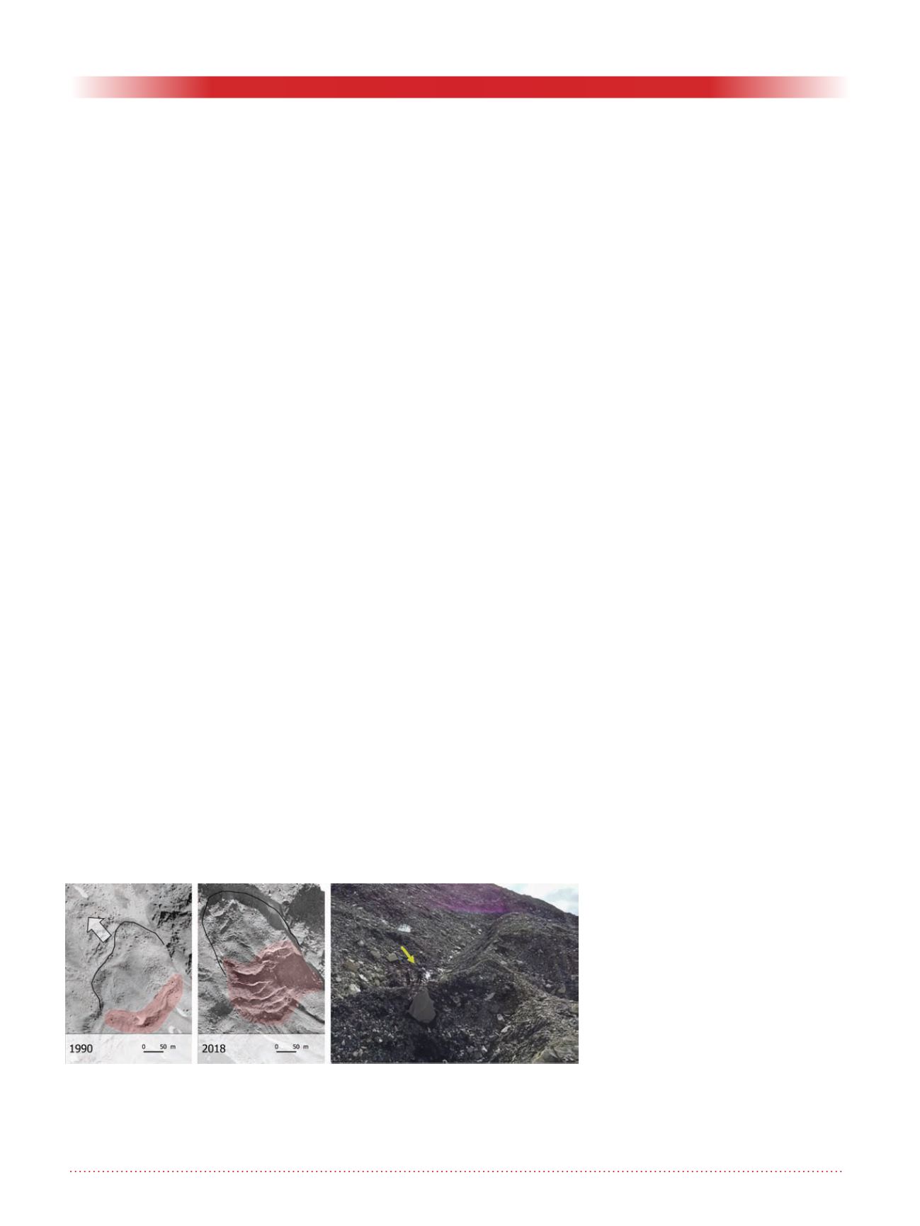
One of the landforms spotted in the
identification phase is presented in
Figure 2. This rock glacier, located on
the North Face of the Longet summit,
encountered destabilization between
2013 and 2015, reaching a displace-
ment rate of 25 m/y in that period.
The destabilization phase started
in the early 2000s as several cracks
started to form on the frontal lobe.
In 2012 a crevasse was initiated and
rapidly developed causing the desta-
bilization phase in 2013. After 2015,
displacement of the landform started
to decrease, and activity will probably
become suspended within few years.
Modelling rock glacier stability
Knowing the locations of destabilized
rock glaciers provides an opportunity
to investigate the settings in which this
process is most likely to occur. Using
a statistical approach, we investigated
the correlation between terrain param-
eters (such as slope angle) and destabi-
lization occurrence, giving important
insights to the underlying drivers of
the phenomenon and allowing for the
identification of other areas that are
favourable to destabilization.
The analysis confirmed some obvi-
ous relationships between the occur-
rence of rock glacier destabilization
and terrain such as on steep convex
slopes, however, we also observed that
the destabilization process was sig-
nificantly more likely on north facing
slopes where solar radiation is weaker.
Although at the current state of the art
it is not possible to provide a convinc-
ing explanation for this phenomenon,
processes linked to higher meltwater
availability in shaded areas through
the summer season may increase the
occurrence of this phenomenon (Ikeda
et al, 2008). In addition, we observed
that destabilization was more likely
to occur at the lower margins of the
permafrost zone. As these areas are
considered to be vulnerable to perma-
frost thaw induced by the average tem-
perature warming, this result implies a
relation between permafrost degrada-
tion and destabilization. This agrees
with several studies that testify to an
intensification of the destabilization
phenomena only in the past two-three
decades (Roer et al, 2008), and is
strongly suspected to be a response to
climate change.
Modelling destabilization
susceptibility
The destabilization process can be
sudden and episodic. If indeed the
phenomena is increasing, then know-
ing the current extent of destabilized
rock glaciers is not enough: it is also
important to identify the rock glaciers
that are susceptible to future destabi-
lization. The modelled susceptibility
Figure 1: Orthoimages showing the evolution of a crevassed area (red
shaded area) of a destabilized rock glacier (location: 45.377, 6.849)
between 1990 and 2018. Rock glacier front (black outlines) moves towards
North-West (direction arrow) about 100 meters. On the right, human scale
(yellow arrow) compared to one crevasse of the same landform in 2017.


