Geotechnical News • June 2018
41
GEO-INTEREST
Geo meshing – Free FLAC3D
®
meshing tool
Alfredo Arenas
Introduction
It has been over five years since the
publication of “New Meshing Algo-
rithm” in GN magazine (Setptember
2012). At that time, the meshing
algorithm was a set of C++ programs,
which allowed creation of complex
meshes, ranging from topographic
shapes to staged earth-fill or excava-
tions.
These set of programs evolved in a
complete package solution, still very
easy to use, but most importantly, the
programs now have graphical interface
and are freely available to public. In
addition, it has been improved with
many features, such as parametric
mesh generation; graphical input
coordinates, mesh refinement, Kriging
interpolations, Bing
®
Maps topo-
graphic resource and parallel process-
ing.
The original article describes the
basis and the technique for creating
the mesh. The article defines the base
2D arrangement mesh for creating a
simple surface, then moves onto the
type of element used in the algorithm,
and finally covers how elements are
connected and oriented.
Although Geo Meshing was spe-
cifically tailored to be used for
FLAC3D
®
, it can still be used with
any other numerical program, as long
as they use node definition and ele-
ment connectivity.
The following shows three real project
examples, were Geo Meshing has suc-
cessfully been used for accomplishing
the hard task of meshing the problem.
Geo Meshing – 3D meshing
software
At Geo Meshing core, one can still
find the collection of C++ programs,
but now they are hidden from the user
and they are called from the main win-
dow. In addition to C++, C# and WPF
programming languages are used.
C# was used to manage all window
interfaces, while WPF was used for
displaying advance graphical shapes
and mouse input.
At the moment of writing this article,
version 2.6.6 is freely available from
its website
). It
needs a license that can be also freely
acquired from its website.
Meshing examples
Creating a Topography from Bing
Maps® Services
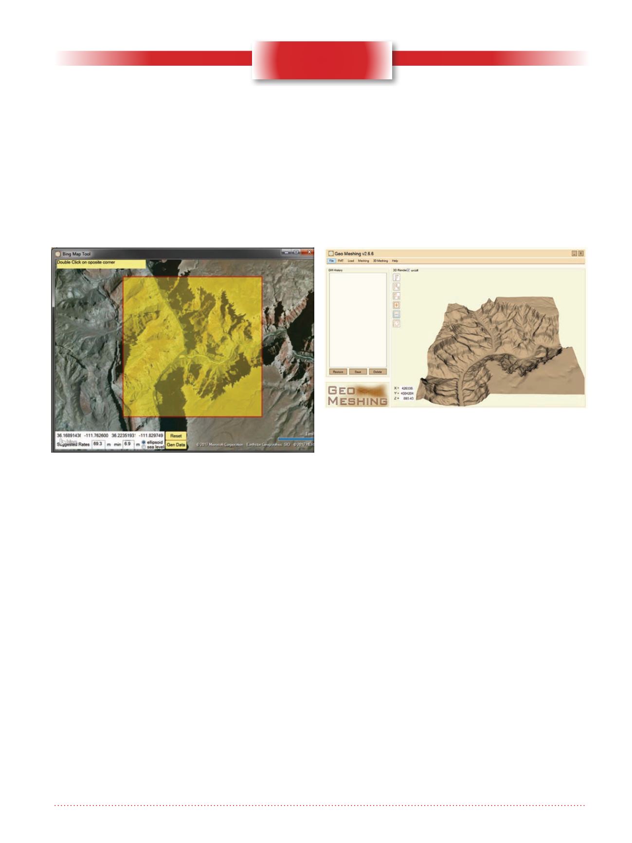
Figure 1 shows the Bing Map® tool
used for navigate the Earth surface
and select an area in any place on the
planet. In this figure an area around
the Grand Canyon has been selected
(yellow highlighted square), by just
double clicking on the map displayed
on the screen. Once the user has sub-
Figure 1. Bing Map® tool built in Geo Meshing.
Figure 2. Imported surface in Geo Meshing


