22
Geotechnical News • September 2018
COMPUTING IN GEOTECHNICAL ENGINEERING
From the GS Board
The mineral soils in the region are
characteristically ice-rich, with ground
ice content typically >20% by volume.
Ice-rich soils limit the infiltration of
water and promote the accumulation
of thick organic material on surface.
Surficial Geology.
The southern third
of the alignment crosses the eastern
extension of the Caribou Hills on the
edge of the Anderson Plain, and con-
sists of mainly ground moraines and
unconsolidated sediments comprising
glaciofluvial, lacustrine, and organics,
with varying quantities of ground ice.
Topographic relief along this sec-
tion reflects the bedrock surface, but
bedrock is rarely exposed. Overburden
is <50 m thick. The northern two-
thirds of the alignment crosses the
Coastal Plain and is littered with lakes.
Unconsolidated sediments include
ground moraines, ice-contact tills,
and glaciofluvial and glaciolacustrine
deposits—all containing ground ice
and massive ice lenses. For design
purposes, the diverse surficial geology
along the alignment was generalized
into morainal, glaciofluvial, lacustrine,
alluvial/colluvial, and organic depos-
its.
Geotechnical permafrost
considerations
The two, more significant, geotechni-
cal design considerations that needed
to be considered were related to
permafrost: the sensitive ice-rich soils
and the management of surface water.
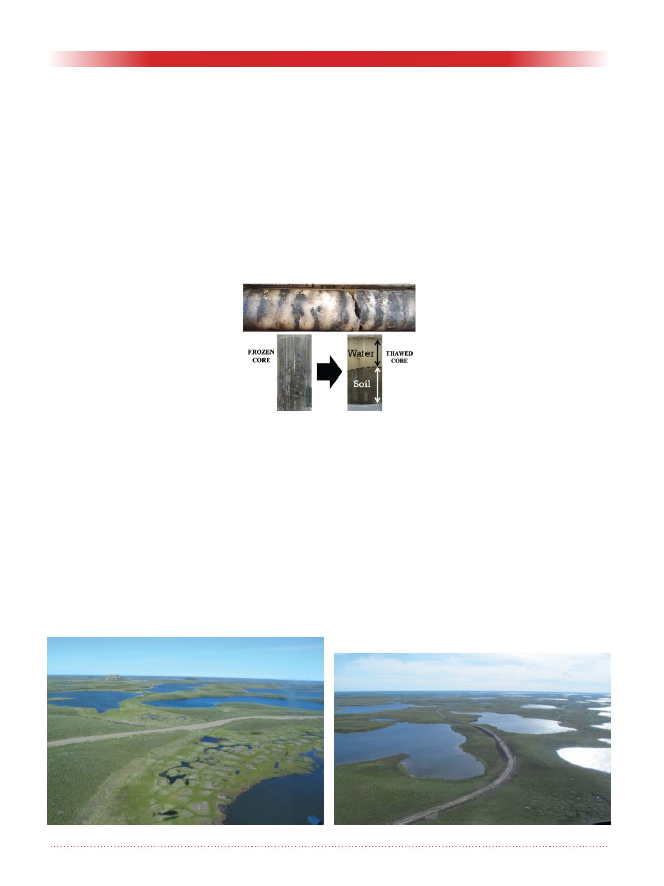
When the amount of water contained
in the frozen soil is greater than in the
soil after thaw, the soil is considered
to be ice-rich. Ice-rich soils are highly
sensitive to thermal disturbances,
which results in thaw settlement (Fig-
ure 2), and can exhibit significant loss
of soil strength and instability when
thawed. Both flowing and ponded
surface water transfer heat from the
water to the ground ice resulting in
thaw conditions.
The primary alignment consideration
was to avoid, where possible, unfvour-
able permafrost terrain distinctive
in the region, including polygonal
ground, thick organics, thermokarst
lakes, retrogressive thaw flow slides
and pingos, while minimizing overall
length.
Polygonal ground
is found primarily
in low-lying, poorly drained areas,
and is indicative of ice-rich soils with
vertical ice wedges forming around
the polygon perimeter and extending
several metres below ground. The ITH
routed around or alongside polygonal
terrain where possible, Figure 3.
Thick organics
deposits, up to several
metres thick, occur as peat, fen or
peat-fen complexes that overlie min-
eral soil, typically on flat terrain.
Thermokarst lakes
develop due to
surface subsidence resulting from the
melting of ice-rich soils where the
surface water cannot drain. The forma-
tion of small lakes leads to further
degradation of the permafrost condi-
tion and lake expansion (Figure 4).
Thermokarst is a slow natural process
that can be aggravated and accelerated
by ground disturbances.
Retrogressive thaw flow slides
occur in
fine-grained, ice-rich soils, and result
from the thawing and subsequent flow
of the ice-rich soils. Failures occur on
very gentle slopes, and over time can
retrogress some distance back from
the escarpment. The alignment was
routed away from existing slides, old
slide scars, and slopes with attributes
that were judged to be susceptible to
failure.
Pingos
(Figure 5) are ice-cored hills
formed by the hydrostatic pressure in
wet areas underlain by ice-rich soils.
They can be up to 50 m high, have a
base of up to 600 m in diameter and
can take centuries to form. Several
large pingos are located near Tuk-
toyaktuk, west of the ITH near the
Beaufort Sea coastline. Pingos are
Figure 2. Ice-rich soil; frozen and
thawed.
Figure 3. Polygonal terrain.
Figure 4. Thermokarst terrain.


