Geotechnical News • December 2018
29
COMPUTING IN GEOTECHNICAL ENGINEERING
From the GS Board
there were no standard methods, and
the full potential of the technology
was unknown. There were few com-
mercially available software packages
for 3D data processing, and none dedi-
cated to geotechnical applications.
In the early 2010s, LiDAR-based
analyses became better documented by
research groups and better understood
within the practicing geotechnical
community. This lead to a willingness
to adopt the technology. Bare-earth
(virtually stripping away of any veg-
etation) airborne LiDAR data became
common for terrain evaluation and a
critical part of assessing geohazards.
Following this adoption, research
shifted to expanding the applications
of LiDAR data with automated data
processing workflows for assessing
differential change between datasets.
In parallel to the acceptance of
LiDAR, the Structure from Motion
(SfM) technique for generating 3D
models from
multiple overlap-
ping photographs
emerged in the
early 2010s. The
SfM method,
originally devel-
oped in 1991,
allowed for high-
resolution, low-
cost, 3D models
and fuelled
research efforts
in the broader
geoscience com-
munity. SfM
3D data genera-
tion techniques,
and advanced
3D processing
approaches, set
the stage for
future develop-
ment of 3D data
processing meth-
ods for landslide
mapping and
failure predic-
tion by allowing
a wider group of
researchers and practitioners to collect
and process data formerly restricted by
the need for expensive equipment.
Researchers’ sustained efforts on
3D remote sensing technologies and
methods, their adoption by practitio-
ners, and the evolution of data quality
and processing capabilities in the past
20 years have generated revolution-
ary methods for detecting change in
natural and constructed environments
with unprecedented levels of accuracy
and spatial extents. High resolution 3D
topological data are transforming how
we map natural terrain and under-
stand movement over time across
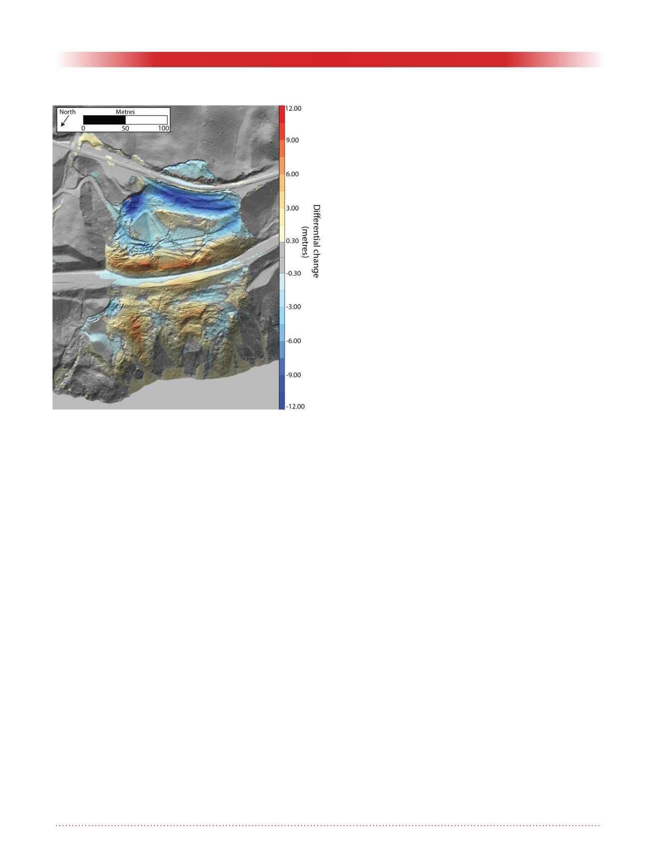
spatially extensive regions (Figure 2,
as an example). Current research to
push processing techniques further
and exploit new data collection and
computational processing capabilities
is changing the foundation of geo-
technical and geoscience topographi-
cal monitoring. Moreover, accuracy
is expected to improve over time,
and the costs of acquisition, process-
ing and interpretation are expected
to decrease. The current challenges
faced when selecting and applying
3D remote sensing technologies are
the need to keep up with their rapid
advancement and expanding capa-
bilities. Collaborative efforts between
researchers and practitioners are
needed to close this gap and provide
the necessary information to those
applying the techniques in practice.
As 3D data collection technologies
and analysis methodologies continue
to evolve, it is critical that we under-
stand the capability of these tools to
solve existing problems, and work
with researchers to solve new ones.
As we shift to designs with perfor-
mance-based metrics, knowing how to
accurately monitor and assess change
will be pivotal to the success of future
projects. LiDAR and SfM are rou-
tinely applied in some industries but
only sparingly in others; this is likely
to change as these new tools find rou-
tine use in the geotechnical profession.
Acknowledgements
The author would like to thank Dr.
Scott McDougall, Dr. Jean Hutchin-
son, Dr. Pete Quinn and Mike Por-
ter for supporting the Colloquium
nomination. Various groups have been
involved in research and consult-
ing projects to support the develop-
ment and adoption of LiDAR in the
geosciences: special thanks to Queen’s
University, Rio Tinto, CN Railway, the
Norwegian Geotechnical Institute, and
BGC Engineering Inc. Specific collab-
orators include: Dr. Mark Diederichs,
Dr. Malte Voege, Dr. Dave Gauthier,
Dr. Ryan Kromer, Tom Edwards,
Mario Ruel, Megan van Veen, Steph
Fekete, Elin Morgan, and Rob Harrap.
Matt Lato Ph.D. Eng.,
P. Eng. (ON, BC, AB, NL)
BGC Engineering Inc.,
414 Princeton Ave. Ottawa ON
K2A 4G2, Tel:613-808-2145
Figure 2: Differential airborne LiDAR analysis conducted
between data collected in 2006 and 2016. Cool colours
indicate negative deformation typical of the upper block
of a landslide subsiding, warm colours indicate positive
deformation typical of a landslide toe deforming outward.


