Geotechnical News • June 2017
23
GEOHAZARDS
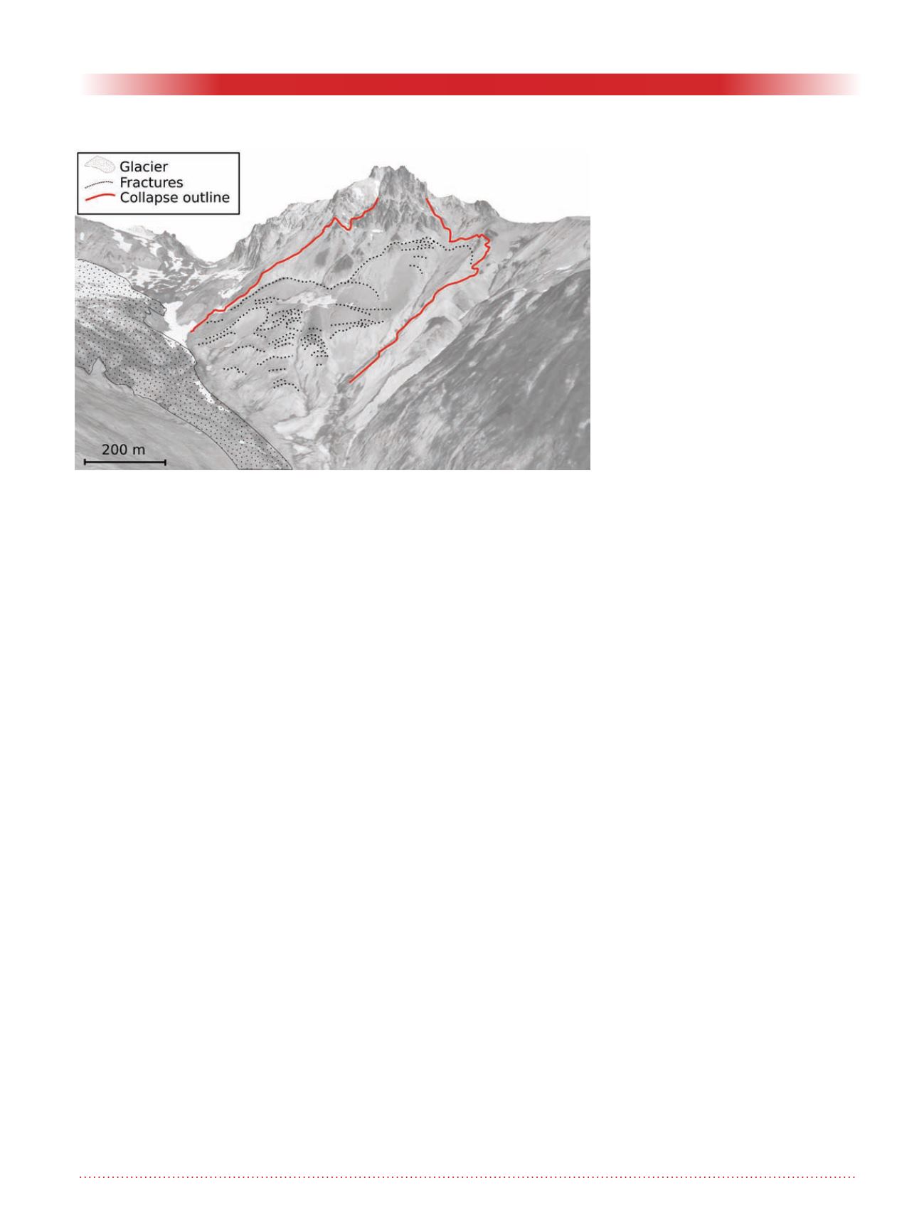
Figure 3. SfM-derived 3D view of Mt Meager before the 2010 collapse. Frac-
tures are evidenced: they indicate active deformation of the slope prior the
collapse. Modified from (Delcamp et al., 2016).
Georeferencing and cartography
accuracy
The standard procedure in georefer-
encing digital geospatial data is to
use coordinates from a source with
higher accuracy. Commonly, GCP
coordinates are measured in the field
during a differential GNSS survey. In
our case, it was not feasible to acquire
GNSS points in the field and the coor-
dinates used for georeferencing the
SfM models were retrieved from the
available Canada imagery and DEMs.
The accuracy of the coordinates used
(10 m planimetric and 18.3 m verti-
cal) in the georeferencing process
was lower than the potential accuracy
of the SfM products (0.8 cm for the
deposit images and 0.5 m -1 m for the
historic photos). The pixel precision
of the models depends on the photo
quality, the original images pixel size
and the matching algorithm. The final
cartographic accuracy depends on the
geographic/cartographic coordinate
source used in the georeferencing
process. During georeferencing other
errors might be introduced when
GCPs have lower accuracy than the
three-dimensional matching. When
the GCPs have higher accuracy than
the bundle adjustment, they might
improve the model quality. When
GCPs are lacking and/or they are not
reliable, the models might be just
scaled for relative volume and area
calculations.
The ability of SfM to build three-
dimensional geometries with relative
object coordinates gives the user the
opportunity of making quick maps
that do not necessarily require GCP
surveys. Observations can be done in
relatively-scaled object-coordinates
without ground control. Careful evalu-
ation of the models is nevertheless
required, especially when GCPs are
not used, to reduce erroneous recon-
structed areas and wrongly projected
points.
Summary
Structure from Motion (SfM) is a
versatile photogrammetric tool that
allows for rapid and high quality
cartographic production. SfM can
reconstruct the three-dimensional
geometry of objects and surfaces in
relative coordinates without the need
for camera calibration parameters,
or GCPs. Geometries and camera
parameters can be retrieved during
bundle adjustments from the redun-
dancy of images. SfM can process
newly acquired overlapping images
as well as digitized historical vertical
aerial photos. Measurements can be
done with geographic coordinates or
relative object coordinates without
the need for precise GCPs. SfM is
becoming a mature technology and a
standard tool for geoscience and can
be effectively applied to the study
of historic landslides deformation to
document ongoing motion or to map
freshly emplaced deposits.
The use of SfM in the detailed study
of the 2010 Mt Meager landslide
deposit, allowed a precise volume
calculation and documentation of
the slow deformation preceding the
collapse. The 2010 Mt Meager land-
slide separated into a water-rich and
a water-poor rheology phases with
different run-out, characteristics and
deposits. The slope prior the collapse
was actively deforming and a glacier
below the flank was retreating.
References
Delcamp, A., Roberti, G., van Wyk de
Vries, B., 2016. Water in volca-
noes: evolution, storage and rapid
release during landslides. Bull.
Volcanol. 78, 87. doi:10.1007/
s00445-016-1082-8
Guthrie, R.H., Friele, P., Allstadt, K.,
Roberts, N., Evans, S.G., Delaney,
K.B., Roche, D., Clague, J.J.,
2012. The 6 August 2010 Mount
Meager rock slide-debris flow ,
Coast Mountains , British Colum-
bia : characteristics , dynamics ,
and implications for hazard and
risk assessment 1–18. doi:10.5194/
nhess-12-1-2012
Roberti, G., Friele, P., van Wyk de
Vries, B., Ward, B., Clague,
J.J., Perotti, L., Giardino, M.,
2017. Rheological evolution of
the Mount Meager 2010 debris
avalanche, southwestern Brit-
ish Columbia. Geosphere 13,
GES01389.1. doi:10.1130/
GES01389.1
Roberti, G., Ward, B., van Wyk de
Vries, B., Friele, P.A., Perotti,
L., Clague, J.J., Giardino, M., in
press. Precursor slope distress
leading up to the 2010 Mount


