 
          
            
              30


            Geotechnical News • March 2012


            GEOTECHNICAL INSTRUMENTATION NEWS


            Remote monitoring of surface deformation with Robotic Total


            Stations using reflectorless measurements (RRTS)


            Damien Tamagnan and Martin Beth


            [Please refer to Tamagnan and Beth,


            GIN Sept 2011, pp 21-24 for more


            details.  Ed.]


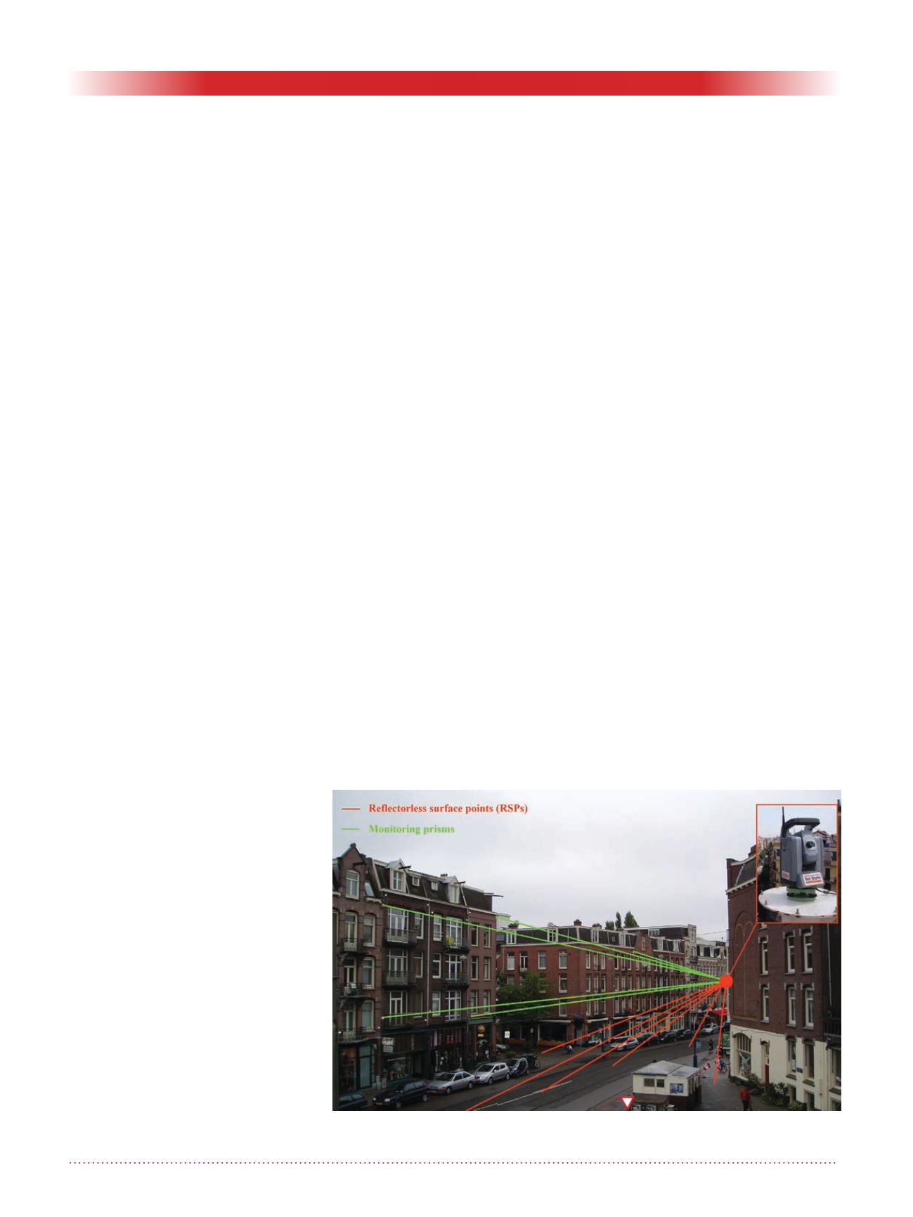
            Principle of operation


          A remote monitoring system able to
        
        
          measure surface deformation 24 hours
        
        
          a day is made up of:
        
        
          • A robotic total station (RTS)
        
        
          equipped with a reflectorless dis-
        
        
          tance meter.
        
        
          • A support platform, electronics
        
        
          box, and 3G or Wi-Fi system.
        
        
          • A data logger which can be oper-
        
        
          ated remotely with specific soft-
        
        
          ware able to drive
        
        
          the total station
        
        
          to the predetermined locations of
        
        
          the monitored points.
        
        
          • Computation software, which can
        
        
          be more or less advanced, for
        
        
          calculating the movements of the
        
        
          points of interest.
        
        
          During each monitoring cycle the
        
        
          instrument sights at (see Figure 1):
        
        
          • The reflectorless surface points
        
        
          (RSPs) on a flat, homogeneous and
        
        
          planar surface for which vertical
        
        
          deformation is to be monitored.
        
        
          RSPs are not physically marked
        
        
          and are not physical objects; they
        
        
          are just a location on the ground at
        
        
          which the RTS is sighting.
        
        
          • The stable reference prisms, which
        
        
          permit computation of the correct
        
        
          position and orientation of the
        
        
          RTS.
        
        
          • If necessary, the same total station
        
        
          and software can sight monitoring
        
        
          prisms installed on structures to be
        
        
          monitored in 3D, as for a standard
        
        
          RTS.
        
        
          On completion of the cycle, the raw
        
        
          and/or calculated data are sent to the
        
        
          database via Wi-Fi or 3G. The system
        
        
          can also trigger alarms sent by SMS or
        
        
          e-mail if predetermined thresholds are
        
        
          exceeded.


            Main fields of application


          Monitoring of road surfaces during
        
        
          underground work.


            Accuracy


          The accuracy of the RRTS method has
        
        
          been confirmed by comparing precise
        
        
          levelling with RSP movements. Exter-
        
        
          nal controls confirmed a consistency
        
        
          better than ±1 mm.


            Main advantages


          • High frequency of readings pos-
        
        
          sible (down to one reading per
        
        
          hour for example)
        
        
          • Uninterrupted traffic, neither for
        
        
          installation nor for taking readings
        
        
          • Very safe, no surveyors on the road
        
        
          • Very cost effective for high fre-
        
        
          quency of readings


            Main limitations


          The range of the distance meter
        
        
          is limited, and so is the angle of
        
        
          incidence of the laser beam on the
        
        
          measured surface. Weather conditions
        
        
          also downgrade the emitted distance
        
        
          meter signal.


            Case histories


          The RRTS method has been well
        
        
          proven in practice in many work sites
        
        
          since 2005.
        
        
          • In Amsterdam (Netherlands) over
        
        
          82 RTS
        
        
          are used to measure more
        
        
          than 5000 RSPs above the tunnel
        
        
          boring machine during the con-
        
        
          struction of the metro line.
        
        
          • In Toulon (France) a network of
        
        
          1830 RSPs has been measured
        
        
          over roads and pavements from 36
        
        
          RTSs during four years.
        
        
          • In Barcelona (Spain) long-term
        
        
          monitoring of the high speed
        
        
          railways tunnel and of Metro Line
        
        
          9 has been set up to monitor settle-
        
        
          ment on roads, sometimes with
        
        
          heavy traffic.


              Damien Tamagnan


            SolData Group, Head of survey


            department, Travesia Industrial,


            149 -3ª C 08907 Hospitalet de


            Llobregat Barcelona (Spain).


            T: +(34) 93 263 29 69.


            E: 


            Figure 1. A Reflectorless Robotic Total Station (RRTS) measuring RSPs and


            prisms.